 Metadata Catalogue
Querel, R.
Type of resources
Topics
Keywords
Contact for the resource
Provided by
Years
Update frequencies
status
-
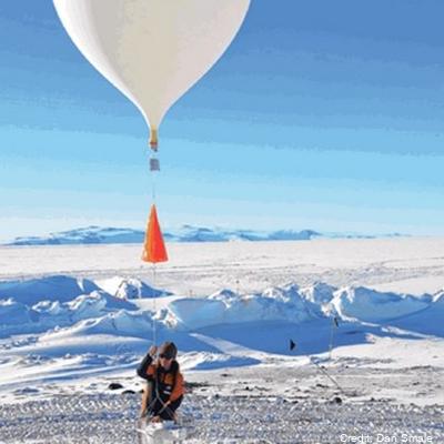
Altitude profile measurements of water vapour, ozone and aerosols using balloon packages flown through the troposphere into the stratosphere as part of the Ross Island GRUAN site activities. Maximum altitude recorded was 29 km. This project is a collaboration between the National Institute of Water and Atmospheric Research (NIWA) and NOAA. Timeline: - November 2022: 2 flights - February 2023: 1 flight - October 2023: 3 flights Data are held internally at NIWA and NOAA, and will be stored in the GRUAN database (https://www.gruan.org/data) GET_DATA: https://www.gruan.org/data
-
Measurements of total column of ozone made with Dobson spectrophotometer that measures either direct or zenith scattered ultraviolet light. The instrument was established in September of 1989 at 77° 49.8'S, 166° 39.6'E. Additionally a Brewer spectrophotometer took total column ozone measurements at Scott from 1989 to 1996. From 1989 to 2006 the Dobson (ID 17) was operated in manual mode but had an electronic encoder and computer added in 2006 for recording measurements. The data acquisition system was upgraded in Febuerary 2015 at Lauder, NZ. It is now running the JMA automation system. The Dobson (instrument ID: D17) is shipped out for maintenance and intercomparison with regional standard Dobson in Melbourne approximately every 5 years. Data (for both Dobson and Brewer) is held internally by NIWA and in the NDACC database. Data is also archived in the ozone and UV data centre Toronto, “Raw” data are times and instrument settings for instrument readings. “Derived” data are column amounts of ozone. Time line: Dobson 1987 -present Brewer 1989-1996 GET DATA: https://www-air.larc.nasa.gov/missions/ndacc/data.html?station=arrival.heights#
-
Spectroscopic measurements of stratospheric gases Nitrogen Dioxide (NO2), Chlorine Dioxide (OCIO), Bromine Oxide (BrO) and Ozone (O3) using scattered sunlight. Airyx and Envimeas: A dual MAX-DOAS UV/visible wavelength diode array spectrometer is deployed to measure of ozone (O3), nitrogen dioxide (NO2), chlorine dioxide (OClO) and bromine oxide (BrO). The instrument is a similar instrument to that of EnviMeas, and produces overlapping datasets with ADAS-2. Fixed azimuth direction, same as the Antarctic Diode Array spectrometer. System 2 (ADAS-2). The data are currently being held internally by NIWA. “Raw” data are times and recorded spectra of scattered light for several viewing directions. “Derived” data are column amount of NO2, OClO, BrO and O3, which can be split into tropospheric and stratospheric parts. This technique is sometimes referred to as MAX-DOAS Multiple-Axis Dual Optical Absorption Spectrometry. This work is carried out in collaboration the University of Heidelberg. ADAS2, Envimeas and Airyx measurements: UV/visible Multi-Axis Differential Optical Absorption Spectroscopy (MAX-DOAS) diode array spectrometers making measurements of ozone (O3), nitrogen dioxide (NO2), chlorine dioxide (OClO) and bromine oxide (BrO). JY: A scanning grating UV/Vis monochromator taking measurements of total slant column of NO2 and Ozone using scattered zenith sunlight. ADAS: A CCD grating UV/Vis grating Acton spectrometer making measurements of total slant column NO2, BrO, OClO and ozone made using scattered light zenith sunlight. Pandora: Direct sun UV/Vis measurements of ozone and NO2. Campaign to test feasibility of long term deployment at Arrival Heights. Instrument timeline JY: 1982 -2023 ADAS: 1993 - 2017 ADAS2: 1998 - present Pandora: 2015 Aug – Oct. Airyx & Envimeas : 2018 – present O3, OCIO and BrO data are in the process of being archived - please contact Richard Querel for data access. NO2 data is available via the "GET DATA" link. GET DATA: https://www-air.larc.nasa.gov/missions/ndacc/data.html?station=arrival.heights